

This week in digital journalism we learned about some verification toys to help tell whether media people share online is real or manipulated. It was SO fun, thanks partly to my (secret) obsession with true crime and partly to my strong need for instant gratification.
Anyway, the point is that I knew the importance of fact-checking and verification and how tough it can be today with all the digital magic tools. What I didn’t realize was how much fun it could be to investigate photos and videos using the amazing tools now available for free to anyone curious to use them. I haven’t yet had time to dig more into First Draft News but if you follow me on Twitter, look out for a tweet storm about their content soon!
Okay, on to the tools. Here are the media I verified, what I used, and how it all went down. If you make it to the bottom of the page, there’s a special challenge waiting!
Verifying photos
 Image: Untitled, from Instagram
Tools used: Google Earth, Google search, Google translator, Instagram
Verified status: Legit!
First I tried the obvious: googled the coordinates cited by the photographer in his post. The location is in the Alps along the border of Italy and Switzerland, which is obviously not right. I just took a trip to the Alps this summer and definitely did not see buildings like these! Given the building style and the presence of umbrellas in the photo, it definitely looks more likely to be a picture of the Umbrella Revolution. Now I just need to prove it.
The photo shows a hill behind an area of fewer-than-typical skyscrapers for Hong Kong. I searched for Admiralty in google earth and zoomed in around the outskirts of the district until I found a place closer to the hilly parts. Then I combed the landscape for an area that looked like an outdoor seating shaped like the one in the photo. I found an elevated area on a Central Government Office building that matched the shape and appearance of the space in the photo and then applied the 3D option. Now I could see that there were tents all over the area at the time the google image was taken: November 2014. But that was definitely the place in the picture. The photographer posted the image of protestors with umbrellas in late September 2014, which was the beginnings of the protests leading to the occupy seen in November in the Google image. Booyah.
Verifying videos
 Video 1: Untitled
Tools used: google earth, google search, google translator, Instagram
Verified status: Legit!
First I watched the video several times, pausing every millisecond or so to see if there was anything readable or any indications of a major landmark. My initial thought was, “What a mess. There is no writing, the footage is not clear, and there aren’t many landmarks. Ugh.” So I took a deep breath and looked at a google map of Antofagasta, Chile and saw it consists of a thin stretch of city between the water and a mountain range. In the video, I could see the characteristics of city lights on a hill and so I could orientate the video according to the geographic features on the map. Well, that’s one clue.
Then I searched generally for earthquake and tsunami alerts in Antofagasta and found several sources covering alerts on the same day the video was posted, April 3, 2015. Okay, so at least I knew that part lines up.
I also came upon a tripadvisor.com review that referenced that Antofagasta is made up mostly of narrow one-way streets. Hmm. Since the video shows a four-lane, two way street, I could narrow down the location to one of a few streets in the city, which was a step in the right direction, but still too much ground to cover by moving up and down google’s street view of each major road looking for the building.
I took a screenshot of the only unique looking building visible in the video and uploaded it to a reverse google search, which did not lead to a match. Bummer.
Afraid I was running into a dead end, I started to search through the videographer’s Instagram account, thinking that since the video seems to be shot at night and from higher than ground lever, the videographer might have been at home, filming from out of a window. I started looking for other photos or videos that could help: similar views, daytime shots, anything that might identify or show the area more clearly.
The first photo I thought looked similar was seemingly in a city area and a translation showed that the photographer referenced a particular area of the city. I google mapped it and found a general area that could be close, but this didn’t provide many clues.
Then, the clouds parted and the Internet Gods gave me my breakthrough. Further back in the Instagram account I found other photos and videos of the same event. On one of the other videos I was just able to make out words on the building I had been trying to identify. I could see “(something) del (something)” and made an educated guess that the first word might be “hospital”. I then googled “antofagasta chile hospital del” and found results for the Hospital del Salvador. A quick image search of the church revealed that it IS the building I was trying to find AND it is located on Aven. Argentina, one of the major streets with two-way traffic. After that it was easy to find the exact location where the video was shot via street view. Mic drop.
 Video 2: 1.18.15 NJ Turnpike I-95 Crash – Black Ice – Trailer
Tools used: Google Earth, Google search, Accident reports from quicktransportsolutions.com, YouTube,
Verified status: Hmm.
So this is a tough one. While I would bet on this video being legit, I have reached a point where I cannot say for sure. Here’s why.
I searched for the location on the NJ Turnpike at the exit shown, and definitely found this exact spot on the interstate, down to the mile marker shown as the car is passing the jack-knifed truck. From here, it gets tricky.
I tried finding an incident report from the trucking company, Estes, but they  do not publicly archive incident reports. Another website, quicktransportsolutions.com has a searchable database of transport truck incident reports, but this particular accident does not come up among the few dozen listed for Estes in the month of January 2015. So I tried searching New Jersey’s accident report database, but to do that you need a vehicle identifier, like a license plate number. I took a screenshot of the license plate of the truck but it’s still a little blurry and I can’t make out the state. The search yielded no results.
A tedious slow motion play of the video gave me some other identifying numbers on the truck, but none of them matched any sort of search and without knowing what those numbers are, those became a dead end as well. I took a look at YouTube’s ‘stats for nerds’ but they didn’t say anything useful for verification, either. Comments? Troll-y.
I searched for police and news reports for the date the video was taken and there were quite a few reports of accidents in New Brunswick due to black ice.
Finally, I gave up when I saw that Storyful has already purchased the rights to this video. If they were able to verify, that’s good enough for me. And that, my friends, is what good journalism is all about. Trust.
 Video 3: Trans Asian Plane Crash
Tools used: YouTube, google search
Verified status: Legit
So, I looked for a really long time for a picture or video to investigate for this piece of the assignment. I did a lot of searching on Instagram, YouTube, and Twitter. I also looked at those annoying ‘recommended stories’ at the bottom of HuffPo. I almost went with this video of a hover boarder I found on Digg (because who knew that is a thing now?!), but it seemed pretty easy to find another hover board that has a Guinness Book Record. No challenge there.
Finally, I just searched YouTube for “viral videos” and found this compilation video. The second video is of an airplane crashing (at about 0:30) into a bridge on a freeway of some sort. The original video has been taken off of YouTube, which made me think it’s either a fake, or someone really doesn’t want this footage on the internet. Either way… I’d found my investigation.
First, I searched the TV station, TVBS, and found that it’s a station in Taiwan that launched in 1995 as the first 24-hour news station there. The station still operates so it’s interesting that the video has been removed.
My next move: a search of “tvbs plane crash.” No sooner had I typed the “cr” google did the rest for me. I already knew this one had been searched a lot. That could be a sign that a lot of people were interested in finding out if the video is real, or a sign that it was real and a lot of people wanted to know more.
Well, here’s the answer to that question: 
Several news sources confirm that this actually happened. I also found another YouTube posting of the incident of another broadcast from TVBS.
It’s unfortunate that this video is legit. The crash took place in February 2015. But just to be certain, I looked at the details more closely.
According to a story from Reuters on the Taiwan’s Aviation Safety Council (ASC) report in July 2015, the pilot of the plane accidentally pulled back on the wrong throttle. The plane clipped the elevated freeway before crashing into a river, killing 43 of the 50 people on board.
Ugh. I should have started with that one.
My takeaway from this assignment is that with advancing digital technology that is more available to everyone, it can be very difficult and time consuming to verify evidence that was once very straight forward. The bright side is that there are more and more tools that help journalists find the truth. There’s hope for #digitaljournalism yet.
BONUS: Thanks for reading to the end of this looooooong post. Here is a little challenge for you. In July David and I visited Barcelona and came upon this little pub. One of these photos is legit and one is bogus. Can you tell which one is which? Leave a comment below and let me know your guess: OBAMA or CAPER!

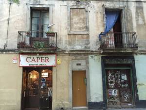
(Here’s a hint: you can find the answer somewhere on this site.)
One thought on “Legit, Bogus, or Hmm… A Lesson in Verification”
I really had a difficulty with this one, partly because I’m lazy and partly because I’m very inefficient at these sort of exercises.
My mini-investigation began to proceed much more efficiently when I simply entered “obama british africa barcelona” into a Google Maps search. There were actually two places called Obama. I clicked on the first listing, a grastro pub called “Obama English Pub Barcelona,” which did not — once I went to Google Street View — have a facade that matched that of the picture featured in this blog. I tried the second listing, which appeared in Google as “Bar Obama” and from the street view saw that I had arrived at what appears to be the correct location, Carrer del Torrent de les Flors, 13, 08024 Barcelona, Spain.
What threw me off was the “38” on the wall of the adjacent location. However, it makes much more sense noe knowing that “Kampa” is at No. 38 Carrer de Bruniquer, which intersects Torrent de les Flors.